
Anthony Licciardello | April 26, 2026

Westfield's Historic Preservation Map is one of the most widely shared and least-understood documents in town. The map shades and labels properties across four distinct categories — but only two of those categories carry any legal weight. Understanding the difference is the single most important thing for any homeowner, buyer, or renovation contractor working in Westfield to grasp before they touch a property with a red dot or sit inside a green-outlined neighborhood.
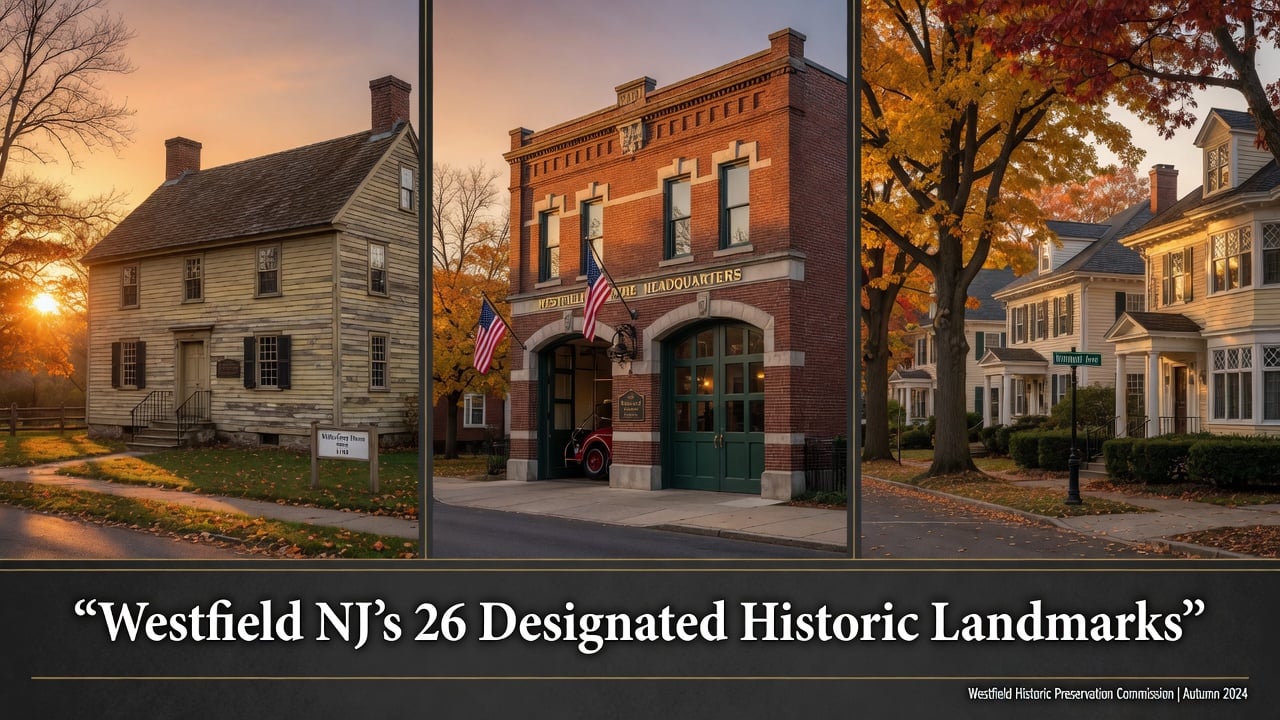
This is the complete address-by-address guide to every legally protected historic landmark in Westfield, drawn from the Town's most current Historic Preservation Map dated February 25, 2025, the 2024 Historic Preservation Master Plan Element adopted by the Planning Board on April 1, 2024, and direct documentation from the Westfield Historical Society and the Town's Historic Preservation Commission.
The Framework
01
"Designated by ordinance" means the Town Council has formally adopted an ordinance — under New Jersey's Municipal Land Use Law — placing the property under the jurisdiction of the Westfield Historic Preservation Commission. Exterior alterations, additions, demolitions, and most visible material changes require a Certificate of Appropriateness from the HPC before the work can proceed. Routine interior work and basic maintenance do not. The HPC was established by municipal ordinance in December 1984. Kimball Avenue, the Town's first historic district, was designated in 1995.
"Identified" is a fundamentally different status. The 2024 Historic Preservation Master Plan Element catalogs 12 historic districts and over 200 individual properties documented in past survey efforts but never formally designated. These properties may carry historic significance and may eventually be nominated for designation, but until that happens, the HPC has no review authority and the Certificate of Appropriateness process does not apply. A homeowner inside the green-outlined Wychwood, Boulevard, or Dudley Park areas on the map can renovate, expand, or in many cases demolish without HPC sign-off. That gap — between identified and designated — is where most of the preservation tension in Westfield currently sits.
Civic & Institutional
02
Nine of Westfield's designated landmarks are civic, institutional, or publicly accessible sites — the museums, monuments, parks, the firehouse, the burial ground, and the small commercial kiosk that anchor the Town's shared historical memory. These are the landmarks Westfielders walk past, drive through, or visit on field trips.
Block 1203, Lot 14 · Map Key I
The oldest structure on the entire designated list. The Miller-Cory House is a circa-1740 farmhouse acquired by the Westfield Historical Society in 1971 and operated since then as a "living museum" staffed by volunteers. The house is open most Sundays from September through June, with weekday access available by appointment. In addition to its local designation, the Miller-Cory House is registered on both the New Jersey and National Registers of Historic Places — one of only a handful of Westfield landmarks that carry all three designations.
Block 2403, Lot 10 · Map Key M
The 1870s home now known as the Reeve History & Cultural Resource Center serves as the headquarters for the Westfield Historical Society. The house was donated to the Town in 1985 by the Reeve brothers with the explicit hope that it would become a permanent home for the Historical Society — a wish that was ultimately fulfilled. Like the Miller-Cory House, the Reeve House carries local designation alongside State and National Register listing.
Block 2405, Lot 14 · Map Key K
The full formal name is the Burial Ground of the Presbyterian Church in the West Fields of Elizabethtown — a name that captures exactly how old this site is. The burial ground dates back to 1720 and contains the graves of founders, original settlers, and Revolutionary War soldiers from Westfield and surrounding communities. The site is locally designated and also listed on the State and National Registers. The 2024 Historic Preservation Master Plan Element specifically recommends pursuing designation of the burial ground together with the adjacent Presbyterian Church at 315 East Broad Street as a single combined historic district.
Block 3103, Lot 6 · Map Key B
The Fire HQ sits at the edge of downtown Westfield within the boundaries of the Master Plan-identified Downtown Historic District. It is locally designated as an individual landmark and is also listed on the State and National Registers. In 2022, the New Jersey Department of Community Affairs recommended a $45,000 grant for stewardship of the historic site. The 2024 Master Plan Element specifically calls for the Town to explore opportunities for adaptive reuse of the historic Fire Headquarters once the active firehouse use eventually ceases.
Block 2403, Lot 12 · Map Key D
The park's name comes from the Lenni-Lenape, the original inhabitants of the area that later became Westfield. Mindowaskin sits in the heart of Westfield directly across from the municipal building and is one of three named parks in town that retain Indigenous names — the others being Tamaques Park and Lenape Park. The park's local designation places it under HPC review for any substantive alterations to its historic character.
Block 2407, Lot 1 · Map Key N
A small designated public park on Mountain Avenue, identified by name in the 2024 Master Plan Element as Triangle Park. Its proximity to the Reeve House and the Presbyterian Church burial ground places it directly within the Mountain Avenue civic spine that concentrates more designated landmarks than any other corridor in Westfield.
North Avenue & East Broad Street · Block 2507, Lot 1 · Map Key A
The WWI monument stands at one of the most prominent intersections in Westfield, where North Avenue meets East Broad Street near the train station. The Plaza location places the monument inside the boundaries of the Master-Plan-identified Downtown Historic District and at the visual center of Westfield's commercial core.
Vicinity of South Avenue Train Station · Map Key O
The smallest designated landmark in Westfield and the only commercial structure on the entire local list. The Coffee Kiosk — preserved near the south side train station platform — is the lone Westfield resource currently designated specifically in connection with the Town's railroad transportation history. The 2024 Master Plan Element notes that despite the railroad's outsized importance to Westfield's late-19th-century development, the kiosk is the only transportation-related landmark on the local register, and recommends that the larger Northside Railroad Station building (already determined eligible for State and National Register listing in 1999) be added through future local designation.
Block 2003, Lot 57 · Map Key J
The Well House is technically a designated portion of a private property — an 18th century well house structure located in front of the Woodland Avenue residence near the road. While it sits on private land, the Well House itself carries individual landmark designation, making it one of the more architecturally unusual entries on Westfield's list and a reminder that designation can attach to a single feature of a property rather than the whole parcel.
A Pattern Worth Naming
03
If you mapped where Westfield's designated civic landmarks actually sit, one corridor would dominate the picture. Mountain Avenue concentrates four of the most significant designated sites within roughly a half-mile stretch: the Miller-Cory House at 614, the Burial Ground of the Presbyterian Church at 125, the William Edgar Reeve House at 314, and Triangle Park at 201. Three of those four are also independently registered on both the State and National Registers of Historic Places.
That concentration is not accidental. Mountain Avenue traces what the 2024 Master Plan Element identifies as the Minisink Trail — an Indigenous trail that ran along present-day Mountain Avenue and predated European settlement. When colonial farms were established in what was then the West Fields of Elizabethtown, they oriented along that pre-existing route. The Miller-Cory House at the western end of the corridor is a direct survivor of that 18th-century farming era. The Presbyterian Church burial ground, dating to 1720, is older still. The Reeve House is a 19th-century overlay on the same corridor, a Victorian-era home that was donated to the Town in 1985 to serve as a permanent base for community history. Mountain Avenue, in other words, is not just where landmarks happen to cluster — it is the historic spine of the Town itself, and the designation pattern reflects three centuries of Westfield's built history layered along a single road.
The Park Cluster
04
Stoneleigh Park is the most architecturally cohesive private enclave in Westfield. The neighborhood was developed as an early-20th-century planned residential community of approximately 30 single-family houses on roughly 20 acres of parklike property, with 29 of the houses arranged on a looped drive that runs diagonally across the park. The Stoneleigh Park Historic District was listed on the State and National Registers in 1998 — the only Westfield district to carry that level of designation. It has not yet been locally designated, although the 2024 Master Plan Element specifically recommends pursuing local designation to give the HPC review authority over exterior alterations within the district.
In the meantime, four individual homes inside Stoneleigh Park have been locally designated as landmarks, and these four sit alongside the state and national district listing as a kind of local protection inserted into a state-and-federal-only district. They are clustered on two contiguous blocks — 4207 and 4209 — and represent the strongest concentration of architectural cohesion among Westfield's designated private residences.
Block 4207, Lot 20 · Map Key U
A locally designated home within the broader State and National Register district. The property is one of two designated landmarks on Block 4207.
Block 4207, Lot 18 · Map Key V
Adjacent to the Piercy-Thomas House, the Beattys House represents the early Colonial Revival period that the 2024 Plan describes as the first of three architectural waves in Stoneleigh Park's development.
Block 4209, Lot 7 · Map Key W
A locally designated landmark on Block 4209, situated on the looped drive that defines the Stoneleigh Park layout.
Block 4209, Lot 2 · Map Key S
Named for Jed Smith Foster, this property is the second locally designated landmark on Block 4209 and one of the key contributing buildings within the State and National Register district.
A Block of Three
05
West Dudley Avenue produced one of the densest local designation sequences in Westfield: three contiguous landmarks on a single block — Block 903 — at lots 41, 45, and 48. Dudley Park itself was primarily developed from the 1880s through the 1920s as a residential extension of Westfield's railroad-suburb era and remains a fine collection of late-19th- and early-20th-century homes that illustrate the architectural variations of the period. The 2024 Master Plan Element identifies Dudley Park as one of the 12 historic districts and specifically recommends extending the proposed district boundaries west to include additional Dudley Park properties — an extension that, if pursued, would surround the three already-designated landmarks with a formally designated district envelope.
Block 903, Lot 41 · Map Key AA
The first of three contiguous designated landmarks on Block 903. Located within the Master Plan-identified Dudley Park Historic District.
Block 903, Lot 45 · Map Key BB
The middle property in the West Dudley designated cluster.
Block 903, Lot 48 · Map Key CC
The third Block 903 designation. The three properties together represent the densest contiguous run of designated private residences in Westfield outside the Stoneleigh Park district.
Individually Designated Homes
06
The remaining ten designated landmarks are private residences scattered across Westfield's blocks, each designated individually on its own merits rather than as part of a cluster or district. These are the homes that earned standalone status — for connection to a notable resident, distinctive architecture, or unique historical significance. One of them is among the most famous houses in Westfield's cultural history.
Block 1102, Lot 4 · Map Key C
The boyhood home of cartoonist Charles Addams — creator of The Addams Family. The house was built in 1907, and the Addams family lived there from 1920 to 1947. Charles Addams's New Yorker career began with the first Addams Family panel published in 1938; many of the cartoon's visual cues trace back to Westfield streetscapes Addams walked as a child. The home is locally designated as a historic landmark and is one of the centerpieces of Westfield's annual AddamsFest celebration. In recent years it has continued to attract significant renovation and Certificate of Appropriateness review activity from the HPC, including approved 2025 plans for a garage addition, rear deck, and replacement windows — a working illustration of how local designation operates in practice on a high-profile property.
Block 1410, Lot 1.01 · Map Key E
A locally designated landmark inside the Master Plan-identified Wychwood Historic District — one of the wooded enclaves Westfield's HPC has prioritized for further research and possible district designation. The historical name reflects multiple generations of the Ball family ownership of the property.
Block 2101, Lot 33 · Map Key F
A surviving farmhouse-era property on East Broad Street, designated locally and named for the Scudder family. Its East Broad Street address places it well east of the Town's commercial core, where the road transitions from downtown into the residential blocks that grew up around the original colonial farm holdings.
Block 3303, Lot 6 · Map Key G
A locally designated private residence on Fourth Avenue, individually nominated and adopted as a landmark.
Block 3408, Lot 12.021 · Map Key H
A locally designated residence on Salter Place. The fractional lot number reflects a subdivision history of the original parcel.
Block 808, Lot 26 · Map Key L
A locally designated landmark on Clark Street in the western portion of Westfield, near the Cranford and Garwood municipal lines.
Block 1004, Lot 10 · Map Key P
An 1870 home and one of the four oldest documented houses on Prospect Street. The Burhans House sits inside the Master Plan-identified Prospect Street Historic District, which the 2024 Plan flagged for boundary reexamination prior to potential local designation.
Block 5604, Lot 5 · Map Key Q
A locally designated residence in the southern portion of Westfield. The high block number reflects the property's location well outside the Town's older central districts.
Block 4813, Lot 32 · Map Key R
A locally designated residence on Central Avenue.
Block 2504, Lot 14 · Map Key T
Documented in the Town's records under the Mills-Ferris-Pearsall name (the property has also been surveyed at the 114 Ferris address as the Joseph Mills House). The home sits inside the Master Plan-identified Prospect Street Historic District boundaries.
The Only Local District
07
Kimball Avenue is, as of this writing, the only locally designated historic district in Westfield. The district was created in 1995 — the first historic district adopted by ordinance in the Town's history — and encompasses 15 properties straddling two blocks (Block 1101 on one side and Block 2401 on the other), with two anchor properties on the adjacent Lawrence Avenue. Every property within the district is subject to HPC review for exterior alterations, additions, and demolitions.
The district is also the policy template for what the 2024 Master Plan Element identifies as a key recommendation: designating more historic districts at the local level, beginning with smaller cohesive enclaves like Stoneleigh Park. Until that happens, the Kimball Avenue district remains the only place in Westfield where being "in a historic district" actually means HPC review applies.
| Address | Block | Lot |
|---|---|---|
| 216 Kimball Ave. | 2401 | 2 |
| 222 Kimball Ave. | 2401 | 3 |
| 230 Kimball Ave. | 2401 | 4 |
| 231 Kimball Ave. | 1101 | 16 |
| 237 Kimball Ave. | 1101 | 15 |
| 242 Kimball Ave. | 2401 | 5 |
| 243 Kimball Ave. | 1101 | 14 |
| 248 Kimball Ave. | 2401 | 6 |
| 249 Kimball Ave. | 1101 | 13 |
| 256 Kimball Ave. | 2401 | 7 |
| 257 Kimball Ave. | 1101 | 12 |
| 265 Kimball Ave. | 1101 | 11 |
| 266 Kimball Ave. | 2401 | 8 |
| 322 Lawrence Ave. | 2402 | 1 |
| 404 Lawrence Ave. | 1113 | 1 |
If You Own One
08
Local designation triggers the Certificate of Appropriateness process. Before exterior alterations, additions, demolitions, or changes to street-visible features can proceed, the property owner submits an application to the Westfield HPC. The Commission reviews the application against published design guidelines, may request modifications, and issues either a Certificate of Appropriateness or a denial. Routine maintenance using in-kind materials, interior work, and changes not visible from public rights-of-way generally do not require review.
In practice, the system works. The 522 Elm Street Charles Addams house is a useful illustration: in 2025 the HPC approved a Major Certificate of Appropriateness for plans to construct an addition to an existing detached garage, add a deck to the rear, and replace windows, fencing, and a lamppost — meaningful work to a high-profile designated property, processed through the formal review path the ordinance creates. The certificate carries a two-year validity from issuance. Designation does not prevent renovation; it shapes what that renovation looks like and how it gets approved. For most Westfield homeowners considering the purchase or sale of a designated property, it's worth reviewing how this process intersects with broader market dynamics, including the actual costs of selling a home in Westfield and how Westfield property taxes are structured.
For broader context on where these landmarks fit within Westfield's current housing market and how preservation considerations interact with the Town's pace of redevelopment, the 2026 Westfield real estate market update provides current pricing, inventory, and trend data. The Town's broader inventory of Westfield communities and neighborhoods is at our communities hub.
Town of Westfield Historic Preservation Map (rev. February 25, 2025). Town of Westfield Historic Preservation Master Plan Element (adopted April 1, 2024; H2M Associates and Easton Architects, prepared with funding from the New Jersey Historic Trust). Westfield Historic Preservation Commission ordinance documentation and meeting minutes. Westfield Historical Society. Charles Addams house dating and ownership history per local reporting and HPC meeting minutes from September 2025 documenting the 1907 construction date.
FAQ
How many historic landmarks are designated in Westfield NJ?
As of the most current Historic Preservation Map dated February 25, 2025, Westfield has 26 individually designated historic landmarks plus the Kimball Avenue Historic District, which is the only locally designated historic district in Town. A second district — Stoneleigh Park — is designated on the State and National Registers but has not been locally designated, so it does not currently fall under HPC review authority.
Does owning a designated historic landmark in Westfield restrict what I can do to my home?
Exterior alterations, additions, demolitions, and changes to street-visible features require a Certificate of Appropriateness from the Westfield Historic Preservation Commission before work can begin. Routine maintenance, interior work, and changes not visible from public rights-of-way generally do not require HPC review. The 522 Elm Street Charles Addams house is a recent working example: in 2025 the HPC approved a Major Certificate of Appropriateness for a garage addition, rear deck, replacement windows, fencing, and a new lamppost.
Are Westfield's "Master Plan-identified" historic neighborhoods legally protected?
No. Identification in the Master Plan flags a property or district as historically significant and as a candidate for future designation, but it does not trigger the Certificate of Appropriateness requirement. Only formal local designation by Town Council ordinance creates HPC review authority. The 2024 Master Plan Element specifically recommends designating more sites and districts at the local level — including Stoneleigh Park — to close that gap.
Is the Miller-Cory House the oldest building in Westfield?
It is the oldest building on the locally designated landmark list, dating to circa 1740. The Miller-Cory House also carries State and National Register listings in addition to local designation. The Burial Ground of the Presbyterian Church, also a designated landmark, is an even older site — its earliest interments date to 1720 — though it is a burial ground rather than a building.
Prodigy Real Estate is an innovative real estate company offering high-end video production, home valuation services, purchasing, and home sales. Serving New York and New Jersey.