
Anthony Licciardello | April 26, 2026
Westfield, NJ
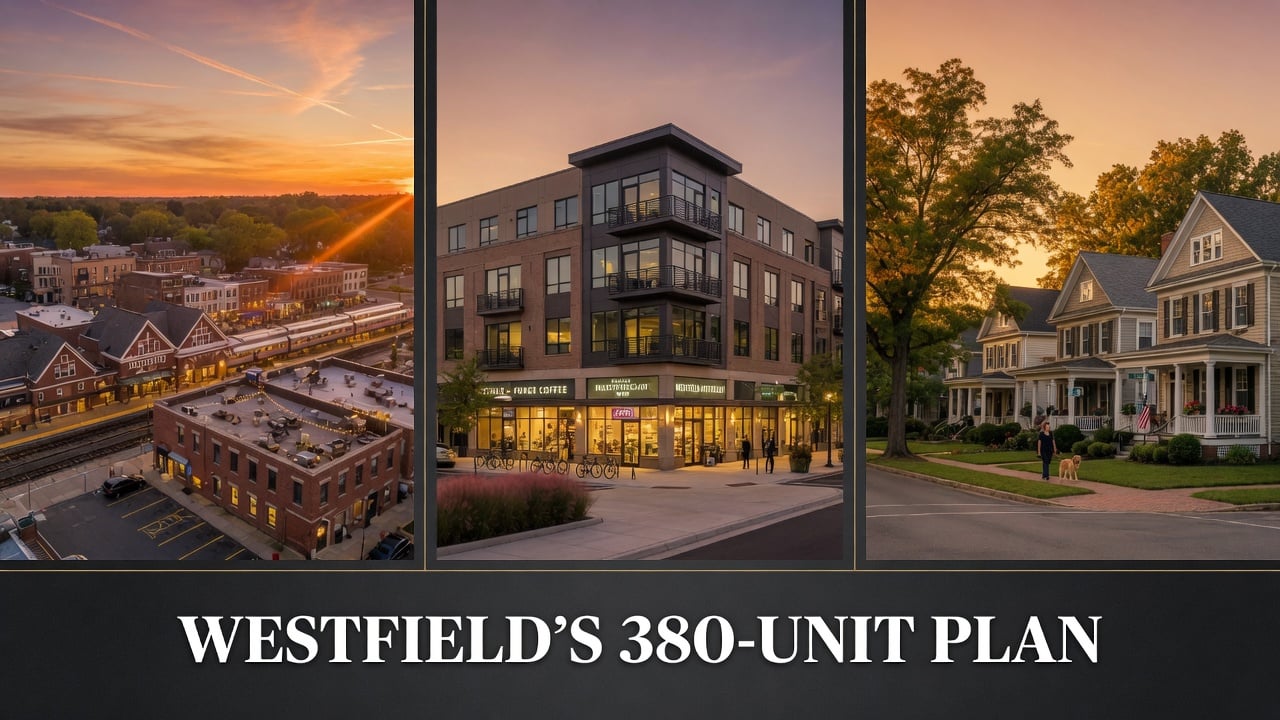
By Anthony Licciardello, The Prodigy Team · April 28, 2026
Three hundred and ninety steps from the Westfield train station, on the north side of South Avenue West, sits a working motor vehicle service station with underground storage tanks. The owner has no obligation to do anything with that parcel. He can keep pumping gas indefinitely. But under a settlement adopted in 2025, the moment that property changes hands or changes use, the underlying zoning permits something very different — a multi-family residential building with a mandatory affordable housing component, four stories tall, at a density of 25 units per acre.
That single parcel is one of five sites Westfield has rezoned within walking distance of the train station to satisfy a court-ordered obligation to plan for 380 new affordable housing units between now and 2035. Most homeowners in town know something is happening near the rails. Almost no one knows the actual number, the actual addresses, or the actual mechanism that holds the entire plan together. This is what the Westfield zoning map looks like in 2026, and what it means for property values inside and outside that half-mile ring.
Before the analysis, the broader context. Our Above the Streets deep dive on Westfield walks through the architecture, the rail history, and the Brooklyn-to-Westfield migration pattern that is reshaping the buyer pool — exactly the demand profile that put pressure on the town to plan for new housing in the first place.
The Number 01
On March 25, 2025, the Westfield Town Council unanimously adopted Resolution No. 93-2025, authorizing affordable housing counsel to settle with the New Jersey Builders Association on the town's Fourth Round Mount Laurel obligation. The number was 380. Three weeks later, on April 14, 2025, the Honorable Daniel R. Lindemann, J.S.C., Designated Mount Laurel Judge for the Union Vicinage, made it official by court order. The Fourth Round runs from July 1, 2025 to June 30, 2035 — a ten-year compliance window during which Westfield must show realistic capacity for those units.*
The settlement followed a brief negotiation. The state's Department of Community Affairs released its initial calculation in October 2024 at 397 units. Westfield filed its own resolution in January 2025 proposing 364. The Builders Association objected. The parties met in late March, agreed on 380, and the judge entered the order. There is no appeal pending. The number is locked.
The Constraint 02
Westfield's own planning documents describe the town as substantially built out. There is almost no vacant developable land left within municipal boundaries. In the Third Round, the town successfully argued for a Vacant Land Adjustment that reduced its zoning obligation from 1,090 units down to a Realistic Development Potential of 68 units. That math worked because the Third Round permitted dramatic adjustments. The Fourth Round framework, written into law in March 2024, is less forgiving.
If you can't find vacant land and you can't argue your way down to a small number, the only strategy left is to concentrate density. That's exactly what Westfield has done. Every one of the five sites adopted in the Fourth Round Master Plan Amendment sits within a half-mile of the train station or directly on a major bus route. None of the five touches a single-family residential zone. The plan deliberately preserves the RS districts that define the town's character and pushes everything new into the commercial corridors along North Avenue and South Avenue.
The Sites 03
The Master Plan Amendment adopted by the Planning Board on May 5, 2025 names all five sites by street address, tax block, and tax lot. Together they total 13.19 acres. All five carry a maximum permitted density of 25 dwelling units per acre. Together they are intended to satisfy at least 25 percent of the adjusted prospective need obligation.*
| Site | Acres | Current Use |
|---|---|---|
| 195–233 Elm Street Block 2505, Lots 4, 5, 6, 7 |
2.80 | Supermarket and vacant commercial buildings; rezoned for mixed-use with ground-floor non-residential and a permitted fourth story |
| 544–576 North Avenue East Block 3305, Lots 1.03, 1.04, 2; Block 3202, Lot 17 |
2.18 | Commercial buildings; 500 feet from NJ Transit Bus Stops #29927 and #29928 on Route 113 |
| 221–341 South Avenue East Block 3204, Lot 9 |
3.87 | Commercial building; within a half-mile of the Westfield rail station |
| 530–600 South Avenue West Block 2510, Lots 18, 19 |
3.13 | Commercial buildings in downtown Westfield; within a half-mile of the rail station |
| 412–436 South Avenue West Block 3101, Lots 2, 3, 4 |
1.21 | Adjacent to the Westfield train station; existing motor vehicle service station with underground storage tanks that may require remediation |
A few details from this list deserve a longer look. The Elm Street site is the largest by frontage and includes an active supermarket — exactly the kind of property that does not redevelop quickly. Affordable housing advocates have flagged this kind of selection as a risk because overlay zoning only converts a property when the owner decides to sell or change use. If the supermarket stays, the housing doesn't get built.
The South Avenue West parcel adjacent to the station is the most consequential of the five for downtown character. It is the closest to the platform, the smallest in acreage, and carries an environmental complication — underground storage tanks that may require remediation as part of any redevelopment. That site, if it ever flips, will reshape the immediate block around the station entrance.
Already In Motion 04
The five overlay sites are the most visible piece of the plan. They are not the only piece. Several projects already in the pipeline or completed will count toward the 380-unit obligation, and one of them is the largest land use change Westfield has seen in a generation.
One Westfield Place is the redevelopment of the former Lord & Taylor properties on North Avenue plus two municipal parking lots, designated to HBC | Streetworks Development in December 2020. The plan adds approximately 315 new residents, new Class-A office space, ground-floor retail, a Boulevard extension connecting North and South Avenues, and 64 deed-restricted affordable units that count toward the Fourth Round.
333 Central Avenue, the luxury rental building, includes 9 units designated as low and moderate income housing inside the existing structure. The Parker at 339 West Broad Street was built on the former car wash site. 753 Grandview Avenue contributes additional units. The Sophia and the American Legion veterans project together added roughly 64 units to the count before the Fourth Round even began.
The Mechanism 05
Overlay zoning is the most misunderstood concept in this whole plan. An overlay zone does not replace the existing zoning. It sits on top of it. The property owner retains every right they had under the underlying commercial designation. They can keep operating a gas station, a supermarket, an appliance store, or any other permitted use indefinitely. The overlay simply adds a second option: if and when the owner chooses to redevelop, multi-family residential with a mandatory affordable housing set-aside becomes a permitted use.
Westfield's land use ordinance now contains at least seven affordable housing overlay districts on top of the underlying zoning: GB1-AHO, GB2-AHO, GB3-AHO, C-AHO, SW-AHO, PA-AHO, and RP-AHO. These overlays sit on top of the General Business and Commercial districts that line North Avenue, South Avenue, and the central business district. The town has also added three full transit-oriented development districts that replace underlying zoning outright: NA-AH on North Avenue, NS-AMFH on New Street, and WBS-AMFH on West Broad Street.
None of these districts existed on the 1998 Westfield zoning map. They are entirely a product of the past seven years of Mount Laurel compliance work. The 1998 map remains the foundation for the town's single-family character — RS-40 along the northern edge near Echo Lake, RS-24 and RS-16 in the larger-lot interior bands, RS-12 and RS-10 across the bulk of established neighborhoods, RS-8 and RS-6 closer to the downtown core. Almost everything that has changed since 1998 has happened within a half-mile ring of the train station.
Property Values 06
The honest answer requires separating short-term construction friction from long-term valuation pressure. They run in opposite directions. In the short term, any property within two or three blocks of an active overlay parcel will see disruption — staging, traffic, equipment, dust, and the occasional variance hearing. That is real and it does suppress sale prices for properties listing during the construction window. We have seen this play out in adjacent towns over the past decade.
In the long term, the data on transit-oriented development is consistent. Walkability premiums for properties within a half-mile of a working commuter rail station have steadily widened across northern New Jersey since the post-pandemic period. Closed-sale data across Union County and Monmouth County shows the half-mile band consistently transacting at higher per-square-foot prices than properties one mile out, holding age, lot size, and condition constant. New rental supply doesn't compete with single-family detached housing — it competes with existing two-family conversions and the regional condo stock. For most homeowners in the established RS districts, the construction phase is the cost; the activated downtown is the benefit.
There is also a less obvious effect worth naming. New Class-A office space at One Westfield Place plus several hundred new downtown residents will drive foot traffic into the central business district. That foot traffic supports the restaurant scene that has quietly become one of the strongest arguments for moving to Westfield in the first place — covered in our separate breakdown of the Westfield restaurant scene. A more vibrant downtown raises the ceiling on what any home in town can sell for over a decade-long horizon.
What To Do 07
For sellers within the affected ring, the action items are straightforward. First, pull a current zoning record on your property before listing. The town's SDL Portal at sdl.town/westfield provides free access to construction permit history, inspections, violations, and prior zoning approvals. Buyers' attorneys are now using that portal during due diligence as a matter of course. Surprises caught before contract are easy. Surprises caught during attorney review are expensive and often kill deals — a dynamic we covered in detail in our breakdown of what it really costs to sell a home in Westfield.
Second, understand your buyer pool has expanded, not contracted. Many of the renters who will live in the new downtown buildings will be exactly the kind of buyer who eventually wants a single-family home a few blocks farther out. We are already seeing this pattern in our Union County and Monmouth County pipelines, and it is consistent with the broader migration we mapped in where NYC buyers are moving in New Jersey.
For buyers, the action items are different. Before your inspection contingency expires, ask three specific questions. Does this property abut or sit within sight of any of the five overlay parcels? What does the SDL portal show for permit history on this exact lot? And what is the underlying zone district — RS-6, RS-8, RS-10, RS-12, or denser — because that determines what the neighbor can build, not what currently exists.
Timeline 08
The Housing Element and Fair Share Plan First Amendment was adopted by the Planning Board on March 2, 2026. That document, paired with the Unified Land Use and Circulation Element Amendment, is the operational blueprint for the next nine years. The Fair Share Housing Center retains the right to monitor implementation and challenge sites that show no realistic path to redevelopment.
The realistic horizon for the five overlay parcels is uneven. The South Avenue West site adjacent to the train station is the most likely to flip in the next five years given its proximity premium and the fact that the existing use carries environmental liability. The Elm Street supermarket site is the least likely — anchor tenants on long-term ground leases rarely move on a Mount Laurel timeline. The remaining three sites depend on owner economics that no plan can fully predict.
One Westfield Place is the one project virtually guaranteed to deliver inside this round. Everything else depends on private property owner decisions that the town can encourage but cannot force. That uncertainty is the entire reason the Builders Association watches these plans closely, and why the next five years in Westfield will look more like an ongoing negotiation than a finished construction sequence. For the broader market context shaping all of this, our Westfield 2026 price update covers the closed-sale data and inventory dynamics in detail.
The plan is on paper. The actual buildings depend on what each owner decides next.
*Sources: Town of Westfield Master Plan documents including the Amendment to the Unified Land Use and Circulation Element of the Master Plan adopted May 5, 2025; the Housing Element and Fair Share Plan First Amendment adopted March 2, 2026; Town Council Resolution No. 93-2025; Order of the Honorable Daniel R. Lindemann, J.S.C., dated April 14, 2025; New Jersey Department of Community Affairs report "Affordable Housing Obligations for 2025-2035 (Fourth Round)" dated October 18, 2024; Town of Westfield Land Use Ordinance Articles 11, 22, and 23; and public planning board records. Site addresses, tax block and lot numbers, acreage figures, and density caps are taken directly from the adopted Master Plan Amendment. Historical context on Third Round compliance and Realistic Development Potential figures comes from town public records and FAQ documentation.
Frequently Asked
Where exactly are Westfield's affordable housing overlay zones?
Five sites were adopted in the May 2025 Master Plan Amendment: 195–233 Elm Street, 544–576 North Avenue East, 221–341 South Avenue East, 530–600 South Avenue West, and 412–436 South Avenue West. All five sit within walking distance of the Westfield train station. Additional overlay districts cover broader segments of North Avenue, South Avenue, Central Avenue, and Ross Place under the prior Third Round plan.
Will an overlay zone next to my house affect my property value?
Short-term, properties immediately adjacent to active construction can see temporary suppression in sale prices. Long-term, properties within a half-mile of a working commuter rail station have generally outperformed properties farther out across northern New Jersey. The biggest factors are direct sightlines to the construction, the eventual quality of the finished building, and how much the new residents activate downtown commerce.
Can the town force a property owner to redevelop into housing?
No. Overlay zoning gives a property owner a second permitted use option but does not require them to use it. The current owner can continue operating their existing business indefinitely. Redevelopment only triggers if and when the owner sells, changes use, or files for a new construction permit on the parcel. This is exactly why some affordable housing advocates challenge overlay-based plans.
How many affordable units will actually be built in Westfield by 2035?
The total court-ordered obligation is 380 units. Existing and pipeline projects including One Westfield Place, 333 Central Avenue, The Parker, 753 Grandview Avenue, the Sophia, and the American Legion veterans project already account for a meaningful share. The five overlay sites cover at least 25 percent of the adjusted obligation if fully redeveloped. Realistic delivery depends on private property owner decisions over the next nine years.
Prodigy Real Estate is an innovative real estate company offering high-end video production, home valuation services, purchasing, and home sales. Serving New York and New Jersey.