
Anthony Licciardello | April 14, 2026
Staten Island Luxury Home Market
The land beneath Todt Hill, Emerson Hill, Grymes Hill, and Ward Hill is not ordinary New York City dirt. It is ancient ocean floor — violently accreted onto the North American continent during a major mountain-building event roughly 450 million years ago known as the Taconic Orogeny. That collision left behind a serpentinite ophiolite complex running through the center of Staten Island. Geologists call it the Serpentine Ridge.
The ridge peaks at 409.8 feet above sea level at Todt Hill — the highest natural point on the Eastern Seaboard south of Maine — and forms the largest exposure of serpentine rock in New York State. The bedrock is composed primarily of lizardite and chrysotile, dense and highly stable minerals that drain efficiently, resist erosion, and make large-scale excavation both expensive and technically demanding.
That last detail matters enormously for real estate. The same geology that defines the ridge physically also makes it practically impossible to develop at density. Blasting through serpentine bedrock is costly, slow, and heavily regulated. The exclusivity of these neighborhoods is not manufactured. The earth itself enforces it. Whatever is built here now is roughly what will always be here.
The hill neighborhoods run 3 to 5 degrees Fahrenheit cooler than the surrounding lowlands during peak summer months. That is not a marginal difference in a metro area where August heat indexes routinely push past 100 degrees. The ridge generates natural wind patterns that reduce humidity and improve air quality — advantages residents feel the moment they drive up from the flatlands below.
Flood protection is the more consequential premium. When Hurricane Sandy made landfall in 2012, lower-lying Staten Island neighborhoods saw several feet of inundation. The Serpentine Ridge sits entirely outside FEMA flood zones. Homes on the hills carry no flood insurance requirements, face none of the elevation certificate demands now standard in coastal markets, and are not exposed to FEMA's ongoing rate revision cycles. In a borough where flood risk has permanently recalibrated buyer psychology, that immunity carries real dollar value.
The ridge is also home to the Serpentine Barrens — a globally rare ecosystem unique to this specific geology. Serpentine rock produces mineral-rich, alkaline soil that supports plant communities found almost nowhere else in the New York City area, including northern bayberry and a range of specialized wildflowers. Because of their ecological rarity, the Barrens are effectively undevelopable. They function as a permanent natural buffer around existing properties. The canopy density on these streets is not going away to make room for a new townhome cluster.
Cooler temperatures, flood immunity, and ecological permanence are not lifestyle amenities layered on top of real estate value. They are structural components of it — features that cannot be replicated on the surrounding flatlands at any price.
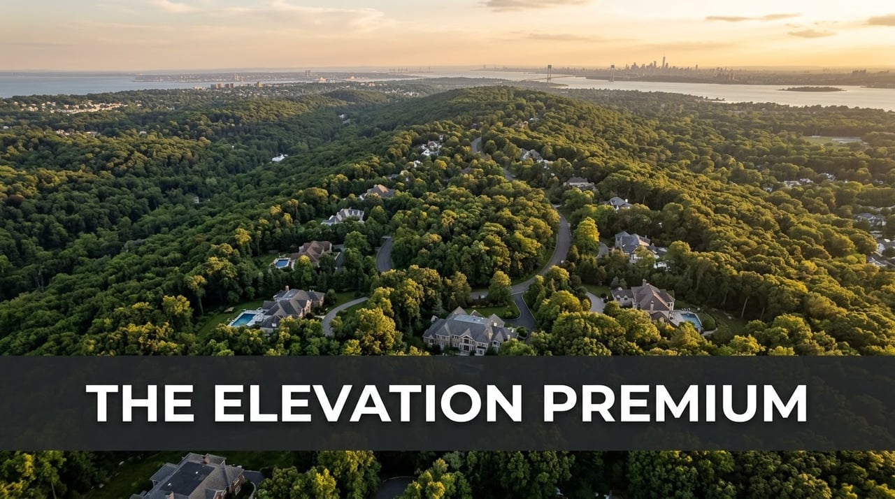
The physical scale of the Serpentine Ridge is difficult to fully absorb from street level alone. The way the ridge drops sharply toward the harbor, the density of old-growth canopy along Todt Hill Road, the clear Manhattan sightline from a single bend on Nixon Avenue — these are things a buyer needs to see before market data makes complete sense. The Prodigy Real Estate video below covers the hill neighborhoods and the luxury market dynamics that define them.
When the Verrazzano-Narrows Bridge opened in November 1964, it connected Staten Island to Brooklyn by road for the first time. What followed was predictable: developers began targeting the island's isolated, elevated hillsides. Within a decade the threat of rapid high-density construction on the central ridge was real enough that the city moved to stop it. In 1974, the Department of City Planning enacted the Special Natural Area District — one of the first natural-area zoning overlays of its kind in the country, specifically designed to protect ecological features rather than simply regulate land use.
SNAD NA-1 governs the central ridge, covering Todt Hill, Emerson Hill, Dongan Hills, and Lighthouse Hill. Its mandate is the preservation of aquatic, biological, botanical, geological, and topographical features — forests, wetlands, and stream corridors included. Practically, this means almost any site alteration, home enlargement, or new construction on a SNAD parcel requires discretionary review by the City Planning Commission. That review evaluates exactly how a proposed change will affect existing trees, natural slopes, and adjacent wetlands. A full breakdown of how SNAD shapes pricing in the Todt Hill market is available in our dedicated neighborhood report.
Even modest improvements can trigger CPC review on a SNAD parcel. Adding a deck, grading a rear yard, expanding a footprint — any of these can require approval before a building permit is issued. That process adds meaningful time and cost to any project, which has the practical effect of discouraging most property owners from attempting anything beyond routine maintenance. The neighborhood you see when you walk a SNAD street today looks nearly identical to how it looked thirty years ago. That is not an accident.
The enforcement backbone is the tree credit system. Any tree with a trunk caliper of six inches or more counts as one credit. SNAD mandates the preservation of mature canopy and imposes strict replanting obligations for any authorized removal. A property owner who clears trees to improve a view or build an addition faces both regulatory penalties and mandatory replanting requirements. The dense, uninterrupted canopy on Todt Hill Road, Douglas Road, and Lighthouse Avenue is not incidental. It is legally protected and has been for fifty years.
For buyers and investors, the practical implication is clear: the supply of homes in SNAD neighborhoods is structurally fixed. No developer can assemble adjacent parcels and build a cluster of new construction on the central ridge. What exists today is the inventory. That condition does not change with market cycles.
Thirteen years after SNAD locked in the central ridge, the city extended comparable protections northward. In 1987, the Special Hillsides Preservation District — a 1,900-acre overlay governing the steep slopes of the northern arc of the Serpentine Ridge — was established. Grymes Hill and Ward Hill fall within its boundaries, along with several other North Shore neighborhoods where the slope topography creates similar environmental fragility.
SHPD's primary concern is slope protection. Steep hillsides stripped of vegetation erode rapidly, generate dangerous stormwater runoff, and are prone to landslides during heavy rain events. The district addresses these risks through a tiered framework. Properties with an average slope under 10% are classified as Tier I sites, subject to baseline development standards. Properties at 10% slope or above fall into Tier II, requiring CPC authorization for any development or site alteration. Properties with a slope of 25% or greater face the most stringent review in the entire framework — a level that applies to a significant portion of the buildable land on both Grymes Hill and Ward Hill.
SHPD enforces the same six-inch tree credit system as SNAD. The combined effect of the two districts is a regulatory envelope covering the entire Serpentine Ridge with no gap. There is no stretch of the ridge that falls outside meaningful zoning protection. Any developer researching new construction on these streets will quickly encounter the same answer: the process is slow, the oversight is intensive, and the economics rarely pencil.
In 2019, the Department of City Planning proposed text amendments intended to streamline both districts — allowing smaller properties to bypass CPC review and replacing certain environmental standards with mandated biodiversity gardens. The Staten Island zoning amendment was formally withdrawn in June 2019 following sustained opposition from residents and environmental groups who argued the proposal would weaken the protections that had defined the ridge for decades. The regulations remain unchanged, and any future attempt to loosen them faces the same political environment that killed the last one.
The Serpentine Ridge does not produce a single panorama. Depending on where along the ridge a property sits — and which direction it faces — the view is either a glittering Manhattan skyline, a monumental suspension bridge over the harbor, or miles of protected forest running to open water. These three distinct corridors represent three distinct buyer profiles, and they explain a meaningful portion of why pricing varies so sharply between neighborhoods sharing the same geological formation.
Properties on the northernmost face of the ridge — concentrated on streets like Nixon Avenue and Ward Avenue in Ward Hill — look directly over the coastal plain toward Lower Manhattan and New York Harbor. Because the land drops steeply from the ridge crest toward the St. George waterfront, there is nothing between these homes and the Financial District skyline. The sightline is unobstructed, and at night, it is dramatic.
Buyers drawn to this corridor are typically urban professionals who want a visual and psychological connection to the city even when they are home. The Manhattan skyline visible from a Ward Hill living room is the same skyline seen from a Park Slope rooftop — framed here by mature trees, a stone wall, and a private driveway instead of neighboring rooftops. That specific contrast is the product these buyers are paying for. The proximity of the St. George Ferry Terminal, offering a free 25-minute commute to the Financial District, amplifies this corridor's appeal for buyers who will not give up an easy Manhattan commute in exchange for more space.
Moving south along the ridge, the primary view corridor rotates east. Homes on the eastern slopes of Grymes Hill and Emerson Hill — streets like Howard Avenue and Douglas Road — look toward the Verrazzano-Narrows Bridge, Brooklyn, and the expanse of the Lower Bay. The bridge's 693-foot towers define this sightline. For buyers here, the bridge functions as a permanent visual anchor rather than a skyline — something fixed and monumental, with maritime traffic moving through the Narrows below providing constant motion against a wide-open sky.
This corridor attracts buyers who want proximity to the city without its aesthetic. The view is cinematic rather than urban — the bridge, the bay, the Brooklyn shoreline in the distance. Pricing on Emerson Hill reflects both the quality of this view and the neighborhood's adjacency to the Greenbelt, which guarantees the sightline from the rear of these properties remains permanently forested. The combination produces a dual-view dynamic rare anywhere in the five boroughs.
At the ridge's highest point, the view inverts entirely. Rather than harbor infrastructure or skylines, Todt Hill looks south and east over the 2,800-acre Staten Island Greenbelt toward Raritan Bay and the open Atlantic. There are no towers or bridges in this sightline. The dominant visual is dense forest canopy extending to open water — and because the Greenbelt is permanently protected parkland, that view will not change.
For the buyer profile that drives Todt Hill pricing — those purchasing estate-sized properties above $2 million on winding, private lanes bordering the Greenbelt — the absence of urban density in the view is the entire point. Privacy here is not a feature of the home. It is a feature of the geography. The Greenbelt absorbs sound, eliminates light pollution, and ensures that the sense of complete removal from the city is not something a new development can eventually compromise.
The three forces covered in this post — serpentine geology, SNAD, and SHPD — do not operate independently. They compound each other. The bedrock physically prevents excavation at scale. The zoning legally prevents clearing and grading on sensitive slopes. The tree credit system prevents the canopy removal that would make marginal parcels more buildable. Together they produce a housing market that structurally cannot respond to demand the way most markets can.
There is no pipeline of new single-family homes on the Serpentine Ridge. There is no assemblage play for a developer looking at Ward Hill or Emerson Hill. The neighborhood density you see on these streets today is effectively permanent. When a Todt Hill estate comes to market, it competes only against other Todt Hill estates — not against a wave of new construction exerting downward pressure on price.
This matters particularly in the current environment. Across Staten Island, active inventory is running well below historical norms as the mortgage rate lock-in effect keeps discretionary sellers sidelined. The 2026 Staten Island luxury market is already defined by constrained supply and sustained demand from buyers crossing the Verrazzano from Brooklyn and Manhattan. On the ridge, those conditions are amplified by constraints that are structural rather than cyclical. They do not ease when mortgage rates fall. They do not resolve when market sentiment shifts.
For buyers evaluating the hill sections, the structural scarcity is the investment thesis. For sellers, it is the foundation of pricing confidence. The broader Staten Island market context reinforces what the ridge's own numbers show: Ward Hill, Grymes Hill, Emerson Hill, and Todt Hill are not simply expensive neighborhoods. They are physically and legally constrained assets in a market with no mechanism to build its way to equilibrium.
Q
What is the Special Natural Area District in Staten Island?
The Special Natural Area District (SNAD) is a zoning overlay established in 1974 covering Todt Hill, Emerson Hill, Dongan Hills, and Lighthouse Hill. It requires City Planning Commission review for any site alteration, new construction, or home enlargement that could affect natural features including trees, slopes, and wetlands. Even modest home improvements on a SNAD parcel require CPC approval before a building permit can be issued.
Q
Why are homes on Todt Hill so expensive?
Todt Hill is the highest natural point on the Eastern Seaboard south of Maine at 409.8 feet above sea level. SNAD zoning effectively prohibits new development, locking supply in place. Lots run from half an acre to full acres — a genuine rarity anywhere in New York City. The neighborhood borders the 2,800-acre Staten Island Greenbelt, sits entirely outside FEMA flood zones, and commands unobstructed southern views toward Raritan Bay and the Atlantic. Median sale prices regularly exceed $1.8 million, with top-tier estates trading above $5 million.
Q
What is the Serpentine Ridge in Staten Island?
The Serpentine Ridge is a geological formation running through the center of Staten Island composed of ancient ocean floor rock — a serpentinite ophiolite complex created during the Taconic Orogeny approximately 450 million years ago. It forms the physical foundation of Staten Island's most expensive neighborhoods: Todt Hill, Emerson Hill, Grymes Hill, and Ward Hill. The ridge peaks at 409.8 feet and contains the largest serpentine rock exposure in New York State.
Q
Can you build new homes on Grymes Hill or Ward Hill?
It is legally possible but heavily constrained. Grymes Hill and Ward Hill fall under the Special Hillsides Preservation District (SHPD), a 1,900-acre zoning overlay requiring City Planning Commission review for any development on lots with an average slope of 10% or more. Properties at 25% slope or greater face the most stringent review in the framework. Combined with the cost of building on serpentine bedrock, these requirements have kept new single-family construction on the northern ridge well below the levels seen elsewhere in the borough.
Prodigy Real Estate is an innovative real estate company offering high-end video production, home valuation services, purchasing, and home sales. Serving New York and New Jersey.