
Homes for sale in Upper Freehold Township, NJ — current 08501 + 08514 listings, median sale prices, the substantial 47.36 mi² substantial substantial substantial largest Monmouth County township by area (substantial substantial substantial primarily rural / agricultural / preserved farmland character), K-12 Upper Freehold Regional School District (Allentown HS Redbirds), substantial Cream Ridge + Imlaystown unincorporated communities, substantial Six Flags Great Adventure proximity (Jackson Township), substantial Assunpink Wildlife Management Area, and substantial substantial preserved horse country + farm character.
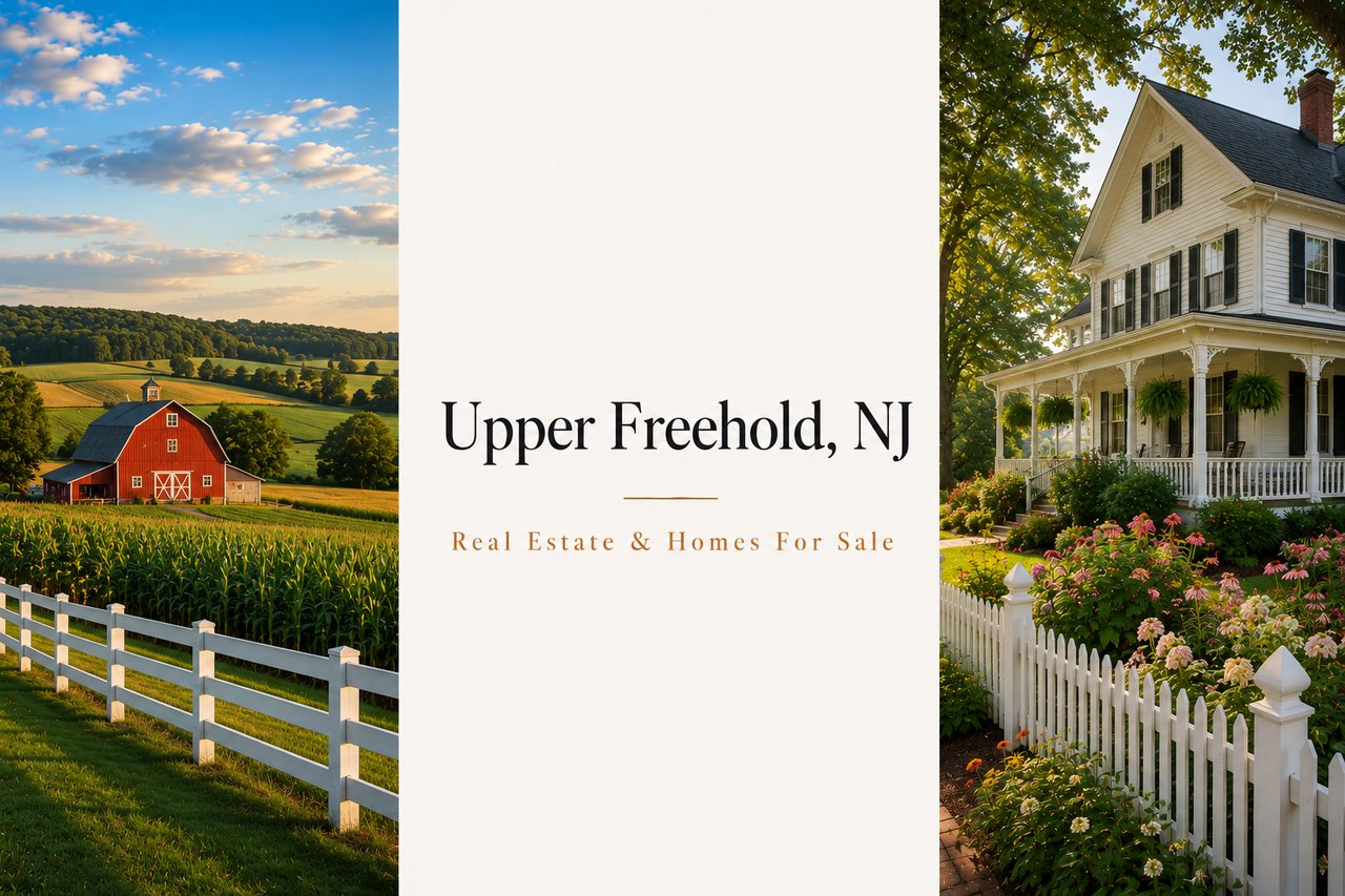
If you're searching for homes for sale in Upper Freehold Township, NJ, you're looking at the substantial 47-square-mile western Monmouth County township branded as "The Heartland of New Jersey" — a pop 7,273 (2020, +5.4% from 6,902 in 2010, +61.2% from 4,282 in 2000 over two decades) substantial agricultural and historic township dating back to 1731 (formally incorporated as a township in 1798). Upper Freehold Township entirely surrounds the substantial Borough of Allentown. Over the years, substantial portions of the township have been taken to form Millstone Township, Jackson Township, and the Borough of Allentown (1889). Township HQ: 314 Route 539, Cream Ridge 08514, phone 609-758-7738. Upper Freehold Township is part of the substantial Upper Freehold Regional School District (PreK-12 regional with Allentown, 27 High Street Allentown, 2,124 students, 12.1:1 ratio, DFG GH, Superintendent Mark Guterl, 3 schools: Newell Elementary PreK-4, Stonebridge Middle 5-8, Allentown HS 9-12). The substantial 10-member Board of Education: 5 elected seats from Upper Freehold Township, 4 from Allentown, 1 appointed by Millstone Township. Substantial unincorporated communities and CDPs within the township include Cream Ridge (CDP, pop 630, 3.04 sq mi total, Freehold sandy loam — substantial richest soil in NJ), Imlaystown, and Arneytown. Upper Freehold real estate trades at a median sale price near $850,000 (Redfin recent +9.7% YoY) with substantial 12-acre estates, substantial preserved farmland, and substantial newer planned-subdivision homes. ZIP codes 08501 (Allentown) and 08514 (Cream Ridge). Substantial 15 miles south of downtown Freehold. Substantial Assunpink Wildlife Management Area.
Upper Freehold Township is the substantial western Monmouth township branded as "The Heartland of New Jersey" — substantial 47-square-mile township that delivers substantial preserved agricultural character (substantial Open Space and Farmland Preservation Committee preserves farmland to the maximum extent possible), substantial Freehold sandy loam (substantial richest soil in NJ — concentrated in the substantial Cream Ridge CDP), substantial Assunpink Wildlife Management Area (substantial NJ Division of Fish & Wildlife-managed substantial natural area), substantial Cream Ridge equestrian / horse-country character (Horse Park of New Jersey nearby), substantial PreK-12 Upper Freehold Regional Schools (the only NJ regional district that operates K-12 with substantial Allentown Borough + Upper Freehold Township composition + substantial Millstone Township board representation), substantial Allentown HS Redbirds (est. 1924, 1,033 students, Colonial Valley Conference), substantial Rutgers Agricultural Research Station, and substantial 12-acre estate and substantial newer planned-subdivision modern home inventory. Upper Freehold Township dates back to 1731, when it was formed from portions of Freehold Township. The township was formally incorporated as a township in 1798. Over the years, substantial portions of the township have been taken to form Millstone Township, Jackson Township, and the Borough of Allentown (1889). Township HQ: 314 Route 539, Cream Ridge 08514 (phone 609-758-7738, [email protected]). Population 7,273 (2020, est. 7,203 in 2023, +5.4% from 6,902 in 2010, +61.2% from 4,282 in 2000). Density 156.5/sq mi (518th of 565 in state, 53rd of 53 in county — the substantial most rural township by density in Monmouth County). Elevation 108 ft. The substantial 47-square-mile total area (313th of 565 in state, 24th of 53 in county by population rank, but 53rd by density rank). Borders Allentown (interior), Millstone Township (NE), Robbinsville Township + East Windsor + Hightstown (Mercer County, W), Plumsted Township (Ocean County, S), New Hanover Township (Burlington County, S), and Cream Ridge CDP centerpiece.
Upper Freehold Township is part of the substantial Upper Freehold Regional School District — a substantial regional PreK-12 district headquartered at 27 High Street, Allentown 08501 (phone 609-259-7292). Enrollment 2,124 students, 176.2 FTE faculty, 12.1:1 ratio, DFG GH (third-highest of eight groupings). Superintendent: Mark Guterl. Business administrator: Nicole Petrone. 3 schools: Newell Elementary School (PreK-4, 27 High Street Allentown), Stonebridge Middle School (grades 5-8, 1252 Yardville-Allentown Road), and Allentown High School (grades 9-12, est. 1924, 1,033 students, Redbirds, Colonial Valley Conference). 10-member Board: 5 from Upper Freehold Township, 4 from Allentown, 1 appointed by Millstone Township. Substantial Interdistrict Public School Choice Program at Allentown HS — 6 Choice Academies. Niche-ranked.
The substantial Cream Ridge CDP is the substantial centerpiece unincorporated community of Upper Freehold Township — pop 630 (2020 census, first census Cream Ridge was listed), 3.04 sq mi total / 3.02 sq mi land, 208.5/sq mi density, elevation 131 ft, ZIP 08514. The soil in Cream Ridge is Freehold sandy loam — among the substantial richest soils in New Jersey. Substantial Miry Run flows westward through the community, joining Crosswicks Creek (forms western edge of CDP). Via Crosswicks Creek, the community is part of the substantial Delaware River watershed. The substantial Rutgers Agricultural Research Station is in Cream Ridge. Substantial center of Cream Ridge at County Route 539 and Burlington Path Road. The substantial Cream Ridge Cemetery is at 173-179 Burlington Path Rd.
The substantial Assunpink Wildlife Management Area — substantial NJ Division of Fish & Wildlife-managed substantial 6,200+ acre natural area substantially preserves substantial forest, fields, lakes, and substantial wildlife habitat across substantial Upper Freehold Township and substantial Millstone Township. Substantial recreational activities include hunting, fishing, hiking, birdwatching, and equestrian use. The substantial nearby Horse Park of New Jersey (in nearby Allentown, adjacent to Upper Freehold) is a substantial New Jersey equestrian event venue with substantial competitions throughout the year. Substantial preservation of farmland and substantial Open Space and Farmland Preservation Committee anchor substantial agricultural character.
Upper Freehold Township's housing stock concentrates in substantial mix of preserved Farmland-Assessed Estate residences (with substantial 12-acre + 20-acre + larger lot footprints), substantial newer planned-subdivision modern homes (substantial tasteful subdivision homes built on substantial smaller-acreage residential lots), substantial substantial Cream Ridge agricultural / equestrian estate residences, and substantial expanded ranch + Cape Cod inventory across the substantial 47-square-mile township. Median sale prices: Redfin recent Upper Freehold Township median sale $850,000 (+9.7% YoY, $317/sqft +1.3% YoY, 64-day DOM, 13 homes sold last period); Homes.com Upper Freehold average home price $1,086,245; Long & Foster 147 homes listed; Redfin 10 land homes for sale at median listing price $856K. ZIP code 08514 (Cream Ridge) median listing $499,000; ZIP code 08501 (Allentown shared) median listing $1,072,500. The substantial rural-suburban / exurb character with substantial preserved farmland drives substantial demand for substantial larger acreage residential estates. Substantial 12-acre Farmland-Assessed Estates with substantial $16,017/2025 taxes per recent listing data. Substantial 20.4 unpreserved acres in heart of Cream Ridge anchors substantial residential potential.
Smaller ranch-style and Cape Cod single-family residences across Upper Freehold Township's substantial more accessible residential blocks. The most accessible Upper Freehold entry point — substantial first-time and primary-residence buyers seeking the substantial rural-suburban township character. The 08514 (Cream Ridge) ZIP code median listing $499,000 anchors this tier. Substantial walking-distance proximity to substantial Cream Ridge centerpiece and substantial Newell Elementary School at 27 High Street, Allentown.
Substantial four-bedroom Colonial and substantial newer planned-subdivision modern single-family residences throughout the township's substantial primary residential blocks. The largest segment by transaction volume — substantial primary-residence year-round families anchored by the substantial Upper Freehold Regional Schools PreK-12 feeder pattern. The Redfin recent median sale $850,000 and Homes.com average $1,086,245 anchor this tier. The 08501 (Allentown shared) ZIP code median listing $1,072,500 represents substantial upper-core inventory.
Substantial Farmland-Assessed Estate residences with substantial 12-acre + 20-acre + larger lot footprints (substantial estates often surrounded by preserved farmland). Substantial custom-build residences with substantial equestrian potential (horse boarding, crop cultivation, Christmas tree farm, winery, brewery, wedding venue) characterize substantial Cream Ridge agricultural estate residences. The substantial Farmland-Assessed Estates have substantial $16,017/2025 taxes (per recent listing data). Substantial 20.4-acre unpreserved estate in heart of Cream Ridge. Among the most-distinctive substantial agricultural estate residential inventory in western Monmouth County.
Upper Freehold Township's substantial 47-square-mile substantial rural-suburban footprint segments by substantial unincorporated CDP and substantial named community pockets — substantial Cream Ridge centerpiece, substantial Imlaystown historic village, substantial Arneytown community, substantial Township Hall corridor (314 Route 539), and substantial Allentown-border residential pockets.
The substantial Cream Ridge CDP — pop 630 (2020), 3.04 sq mi total / 3.02 sq mi land, 208.5/sq mi density, elevation 131 ft. The substantial center of Cream Ridge at County Route 539 and Burlington Path Road. Substantial Freehold sandy loam (the substantial richest soil in NJ). Substantial Miry Run flows westward through the community, joining Crosswicks Creek. Substantial Rutgers Agricultural Research Station. Substantial Cream Ridge Cemetery (173-179 Burlington Path Rd). The substantial New Jersey United Christian Academy (73 Holmes Mill Rd, 609-738-2121). Substantial equestrian / agricultural estate residential inventory throughout.
The substantial Imlaystown unincorporated community — substantial preserved historic village in eastern Upper Freehold Township. Substantial colonial-era settlement. Substantial Imlaystown Lake recreational anchor. Substantial preserved historic residential inventory with substantial estate-scale parcels. Among the most-watched substantial preserved-village residential pockets in western Monmouth County.
The substantial Township Hall civic corridor — anchored by Upper Freehold Township municipal building at 314 Route 539, Cream Ridge 08514 (phone 609-758-7738, [email protected]). Substantial Construction Official (ext. 222), Health Department (ext. 224), Office of Emergency Management (ext. 220), Public Works (ext. 227), Recreation (ext. 212), Senior Citizens (ext. 111), Tax Collector's Office (ext. 214), and Tax Assessor (ext. 219). The substantial Open Space and Farmland Preservation Committee operates from the substantial civic infrastructure.
The substantial Assunpink Wildlife Management Area corridor — the substantial NJ Division of Fish & Wildlife-managed substantial 6,200+ acre preserved natural area straddling Upper Freehold Township and Millstone Township. Substantial preserved forest, fields, lakes (including Assunpink Lake), and substantial wildlife habitat. Substantial recreational activities include hunting, fishing, hiking, birdwatching, and equestrian use. Substantial residential pockets adjacent to the substantial preserved wildlife management area.
The substantial Allentown Border eastern Upper Freehold pocket — bordering the substantial Borough of Allentown (Upper Freehold entirely surrounds Allentown). Substantial residential blocks adjacent to substantial Allentown Historic District (220+ preserved historic structures) and substantial Upper Freehold Regional Schools HQ + Allentown HS at 27 High Street. Substantial primary-residence year-round families anchor substantial residential continuity along the substantial Upper Freehold-Allentown border.
"Upper Freehold Township — 'The Heartland of New Jersey' — is the substantial 47-square-mile western Monmouth township that dates back to 1731 (formally incorporated 1798) and entirely surrounds the Borough of Allentown. With substantial preserved farmland (Open Space and Farmland Preservation Committee), Freehold sandy loam (richest soil in NJ, concentrated in Cream Ridge CDP), Assunpink Wildlife Management Area, PreK-12 Upper Freehold Regional Schools (Newell Elementary + Stonebridge Middle + Allentown HS Redbirds), and median home sales $850K (+9.7% YoY) with substantial 12-acre Farmland-Assessed Estates and substantial Cream Ridge equestrian properties, Upper Freehold Township is one of western Monmouth's most-distinctive substantial agricultural townships."
Upper Freehold Township cross-shops most directly with the substantial Borough of Allentown (which Upper Freehold entirely surrounds — substantially smaller 0.6 mi² historic borough, same Upper Freehold Regional Schools K-12), substantial neighboring Millstone Township (substantial K-8 own MTRSD + sending 9-12 to Allentown HS via separate sending/receiving relationship), substantial Roosevelt (substantial small western Monmouth borough nearby, K-5 own + 6-12 East Windsor Regional sending), and Plumsted Township (Ocean County immediately south).
Town | Median Sale | Avg. Tax | Land Area |
|---|---|---|---|
Upper Freehold Twp ★ | $850,000 | $12,400 | 47 mi² |
$440,210 | $8,800 | 0.59 mi² | |
Millstone Township | $795,000 | $12,300 | 36.7 mi² |
$458,000 | $9,800 | 1.95 mi² | |
Plumsted Township (Ocean) | $485,000 | $7,800 | 40.9 mi² |
★ Subject town. Sources: Monmouth County Board of Taxation (2025 certified data), Upper Freehold Regional School District NCES data (PreK-12 regional, 2,124 students, 3 schools, 12.1:1 ratio, DFG GH, Superintendent Mark Guterl); Allentown HS est. 1924, 1,033 students, 13.7:1, Redbirds, Colonial Valley Conference; Redfin recent Upper Freehold Township median sale $850,000 (+9.7% YoY, $317/sqft, 64-day DOM, 13 homes sold); Homes.com average home price $1,086,245; Cream Ridge CDP pop 630 (2020), 3.04 sq mi, Freehold sandy loam; Upper Freehold Township dates back to 1731, formally incorporated 1798. Upper Freehold pricing varies substantially by section — verify section-specific pricing with The Prodigy Team before contract.
Township History. Upper Freehold Township dates back to 1731, when it was formed from portions of Freehold Township. The substantial township was formally incorporated as a township in 1798. Over the years, substantial portions of the township have been taken to form Millstone Township (1844 — separated from Upper Freehold), Jackson Township (1844 — in Ocean County, separated from Upper Freehold and Freehold), and the Borough of Allentown (1889 — incorporated as a borough from portions of Upper Freehold). The substantial township is governed under New Jersey's Township form of government. Township HQ: 314 Route 539, Cream Ridge 08514 (phone 609-758-7738). Population 7,273 (2020, est. 7,203 in 2023). Substantial +5.4% from 6,902 in 2010, and substantial +61.2% from 4,282 in 2000 — substantial growth over two decades. Density 156.5/sq mi (518th of 565 in state, 53rd of 53 in county — the substantial most rural township by density in Monmouth County). Elevation 108 ft. Total area approximately 47 sq mi. ZIP codes: 08501 (Allentown shared) and 08514 (Cream Ridge).
Upper Freehold Regional School District (PreK-12). Upper Freehold Township is part of the substantial Upper Freehold Regional School District — a substantial regional PreK-12 district headquartered at 27 High Street, Allentown 08501 (phone 609-259-7292). Enrollment 2,124 students 2021-22 (Niche 2,039 PK, K-12), 176.2 FTE faculty, 12.1:1 ratio, DFG GH (third-highest of eight groupings). Superintendent: Mark Guterl. Business administrator: Nicole Petrone. 3 schools: Newell Elementary School (PreK-4, 27 High Street Allentown), Stonebridge Middle School (grades 5-8, 1252 Yardville-Allentown Road Allentown), and Allentown High School (grades 9-12, est. 1924, 1,033 students 2024-25, 13.7:1 ratio, Principal Todd Pae, Redbirds, Red and Black, Colonial Valley Conference). 10-member Board: 5 elected from Upper Freehold Township, 4 from Allentown, 1 appointed by Millstone Township. The substantial district participates in the Interdistrict Public School Choice Program at Allentown HS — approved November 2, 1999, as one of the substantial first ten districts statewide. Substantial 6 Choice Academies: Agricultural Science Academy, Arts Academy, Engineering Academy, Tomorrow's Teachers Academy, Academy of Public and International Affairs, and Academy of Advanced Math and Algebra. Substantial Advanced Level Mathematics (ALM) Program. Niche state test scores: 48% math proficiency, 57% reading proficiency. Substantial New Jersey United Christian Academy in Cream Ridge as substantial private school option.
Cream Ridge CDP + Freehold Sandy Loam + Rutgers Agricultural Research Station. The substantial Cream Ridge CDP is the substantial centerpiece unincorporated community of Upper Freehold Township — pop 630 (2020 census, first census Cream Ridge was listed), 3.04 sq mi total / 3.02 sq mi land / 0.023 sq mi water, 208.5/sq mi density, elevation 131 ft, ZIP 08514. The soil in Cream Ridge is Freehold sandy loam — among the substantial richest soils in the state of New Jersey. Substantial Miry Run flows westward through the community, joining substantial Crosswicks Creek (forms western edge of CDP). Via Crosswicks Creek, the community is part of the substantial Delaware River watershed. The substantial Rutgers Agricultural Research Station is substantially adjacent to substantial preserved farmland in the area. The substantial center of Cream Ridge at County Route 539 and Burlington Path Road. The substantial Cream Ridge Cemetery at 173-179 Burlington Path Rd. The substantial New Jersey United Christian Academy at 73 Holmes Mill Rd. Substantial unincorporated communities and CDPs within the township include Cream Ridge, Imlaystown, and Arneytown.
Assunpink Wildlife Management Area + Real Estate + Transportation. The substantial Assunpink Wildlife Management Area — substantial NJ Division of Fish & Wildlife-managed substantial 6,200+ acre natural area substantially preserves substantial forest, fields, lakes (including substantial Assunpink Lake), and substantial wildlife habitat across substantial Upper Freehold Township and substantial Millstone Township. Substantial recreational activities include hunting, fishing, hiking, birdwatching, and equestrian use. Substantial 5K-6K race events at Assunpink. The substantial Open Space and Farmland Preservation Committee preserves farmland to the maximum extent possible in a manner that is reasonable, achievable and equitable to the farmer. Substantial median sale price $850,000 (Redfin recent, +9.7% YoY, $317/sqft, 64-day DOM). Substantial Homes.com average home price $1,086,245. Substantial 12-acre Farmland-Assessed Estates with $16,017/2025 taxes per recent listing data. Substantial 10 minutes from NJ Turnpike Exit 8, I-195, and Route 130. Substantial Route 539 main north-south road through township. Substantial Old York Road historic colonial route. Substantial nearby Horse Park of New Jersey equestrian event venue. Substantial 15 miles south of downtown Freehold.
The median sale price in Upper Freehold Township tracks at approximately $850,000 per Redfin recent data (+9.7% YoY, $317/sqft, 64-day DOM, 13 homes sold last period). Homes.com average home price $1,086,245. ZIP code 08514 (Cream Ridge) median listing $499,000; ZIP code 08501 (Allentown shared) median listing $1,072,500. Substantial 12-acre Farmland-Assessed Estates with $16,017/2025 taxes per recent listing data. Substantial 20.4-acre unpreserved estates in heart of Cream Ridge. Average tax bill approximately $12,400. The substantial rural-suburban / exurb character with substantial preserved farmland drives substantial demand for larger acreage residential estates.
Upper Freehold Township is part of the substantial Upper Freehold Regional School District (PreK-12 regional, 27 High Street, Allentown 08501, 2,124 students, 12.1:1 ratio, DFG GH, Superintendent Mark Guterl). 3 schools: Newell Elementary School (PreK-4), Stonebridge Middle School (grades 5-8, 1252 Yardville-Allentown Road), and Allentown High School (grades 9-12, est. 1924, 1,033 students, 13.7:1 ratio, Principal Todd Pae, Redbirds, Colonial Valley Conference). The substantial 10-member Board of Education: 5 from Upper Freehold Township, 4 from Allentown, 1 appointed by Millstone Township. The substantial district participates in the Interdistrict Public School Choice Program at Allentown HS (approved November 2, 1999). The substantial New Jersey United Christian Academy in Cream Ridge is a substantial private school option.
Cream Ridge is a substantial unincorporated community and Census-Designated Place (CDP) within Upper Freehold Township. Population 630 (2020 census, first census Cream Ridge was listed); total area 3.04 sq mi (3.02 sq mi land + 0.023 sq mi water); density 208.5/sq mi; elevation 131 ft. ZIP code 08514. The soil in Cream Ridge is Freehold sandy loam — among the richest soils in the state of New Jersey. Substantial Miry Run flows westward through the community, joining Crosswicks Creek (forms western edge of CDP). Via Crosswicks Creek, the community is part of the Delaware River watershed. The substantial Rutgers Agricultural Research Station is substantially adjacent to preserved farmland. The substantial center of Cream Ridge is at County Route 539 and Burlington Path Road. Substantial equestrian / agricultural estate residential inventory.
Upper Freehold Township dates back to 1731, when it was formed from portions of Freehold Township. The substantial township was formally incorporated as a township in 1798. Over the years, substantial portions of the township have been taken to form Millstone Township (1844), Jackson Township (1844 — Ocean County, separated from Upper Freehold and Freehold), and the Borough of Allentown (1889 — incorporated as a borough from portions of Upper Freehold). The substantial township entirely surrounds the substantial Borough of Allentown. Substantial 47-square-mile total area. Substantial preserved agricultural character anchored by substantial Freehold sandy loam (richest soil in NJ) and substantial Open Space and Farmland Preservation Committee. Substantial unincorporated communities include Cream Ridge, Imlaystown, and Arneytown.
The Prodigy Team works the Cream Ridge / County Route 539 centerpiece, the Imlaystown historic village pocket, the Township Hall / Route 539 civic corridor (314 Route 539 Cream Ridge), the Assunpink Wildlife Management Area corridor, and the Allentown border / eastern Upper Freehold residential blocks every week. Cinematic 4K aerial drone marketing — particularly valuable for Upper Freehold's substantial Farmland-Assessed Estates with 12-acre + 20-acre + larger lot footprints, substantial Cream Ridge agricultural / equestrian estate residences, and substantial preserved farmland surrounding the substantial 47-square-mile township — NYS/NJ broker representation, and 20+ years of Monmouth County transactional experience.
Prodigy Real Estate is an innovative real estate company offering high-end video production, home valuation services, purchasing, and home sales. Serving New York and New Jersey.